Joining several other cities around the country working to support social distancing efforts by limiting and slowing car traffic on certain city streets, Mayor Libby Schaaf announced Oakland Slow Streets, an emergency measure, this past Friday.
Where and Which Streets in Oakland?
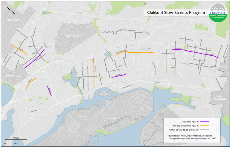
This program started with a pilot Saturday, April 4 with signage along the following four street segments:
- West St: West Grand – 14th Street
- Arthur St from Havenscourt Blvd – 78th Ave, connecting to Plymouth St from 78th – 104th Avenue
- E 16th St: 23rd Ave/Foothill Blvd – Fruitvale Ave
- 42nd St: Adeline – Broadway
**4/16/2020 Update** On Tuesday (April 14) the City announced it had identified 11 additional miles of Slow Streets from which to select 4-5 miles for the second phase of streets to receive “soft closures” beginning this Friday, April 17, and requested community input about this proposal.
After considering feedback from the community, the City has selected the following streets from the candidates identified in the April 14 announcement to receive signage and barriers as part of the Slow Streets Program expansion on April 17, representing an additional 4.6 miles:
- 11th Ave/ Bayview Ave/ Elliot St/ E 34th St – From E 8th St to Park Blvd
- 32nd St – From Mandela Pkwy to San Pablo Ave
- Brookdale Ave – From Fruitvale Ave to Kingsland Ave
- Dover St – From Alcatraz Ave to 52nd St
City staff have received requests for a more interactive map identifying the expanded streets, and to meet that request have produced this searchable, zoomable map: https://arcg.is/0W54bD
This program is also intended to discourage drivers from using ALL Oakland Slow Streets unless necessary to reach a final destination, and urges all drivers to drive slowly and safely, expect to see people walking and biking along ALL streets, as our hospitals are facing unprecedented challenges and don’t need any additional patients. This effort does not impact emergency vehicle access in any way.W
“Oakland Slow Streets” does the following:
- Declare “Road Closed to Through Traffic” on all Oakland Slow Streets for the Duration of the Emergency or until otherwise indicated by the City of Oakland. (74 miles, nearly 10% of Oakland streets; see map on this page.) Note: these streets are not closed to emergency vehicles or local traffic that must use these streets to access a final destination.
- City Provided Signage/Barricades at Key Locations. At selected locations, such as intersections with arterial streets, post closure signage. The City will prioritize posting signage on routes in underserved communities.
- Promote Physically Distant Physical Activity. With nearly 10% of City streets identified as closed to through traffic, residents can safely distance themselves from neighbors when walking, jogging, and biking along these streets. Always maintain at least 6 feet of space from others.
- Amplify the City’s Capacity with Partners. Work with community organizations and civic leaders to complement City-led interventions – communications and outreach, additional signage, evaluation, and potential community-designed traffic calming (“tactical urbanism”); building up participation over time, subject to observation/evaluations.
- Measure Impact and Modify Overtime. Our cities are adapting faster than ever before due to COVID-19. The program plans to evaluate the efficacy of our efforts overtime and make any relevant adjustments.
“Oakland Slow Streets” doesn’t do the following:
- Encourage social gathering or events on any of these streets. Always maintain at least 6 feet of physical space from others.
- Limit access for emergency vehicles or close streets to people that must use them to access a final destination.
- Seek to ticket or financially penalize those who use the corridors as through streets.
- Affect AC Transit bus routes or service.
What Does It Mean?
The program is intended to support safe physical activity by creating more space for physical distancing for all Oaklanders by declaring that all existing and proposed Neighborhood Bike Routes are Closed to Through Traffic so that people can more comfortably use these low-traffic streets for physically distant walking, wheelchair rolling, jogging, and biking all across the City.
Updates will be provided on the City of Oakland website.