
The following weather commentary is from climate scientist Daniel Swain, aka @weather_west on social media. Swain studies the changing character, causes, and impacts of extreme weather and climate events on a warming planet–with a particular focus on the physical processes leading to droughts, floods, and wildfires. He holds a PhD in Earth System Science from Stanford University and a B.S. in Atmospheric Science from the University of California, Davis. His full curriculum vitae is available here.
An atmospheric “Rube Goldberg” machine will lead to complex pattern evolution
The upcoming pattern across the Western U.S. is going to be a complex one–the result of a series of concatenating unusual occurrences in the coming days that I’m an “atmospheric Rube Goldberg machine.” (FWIW, nearly all atmospheric interactions can be conceptualized as a naturally emergent yet highly elaborate Rube Goldberg machine, though sometimes the pathway is more traceable than at other times! This is one of those times.)
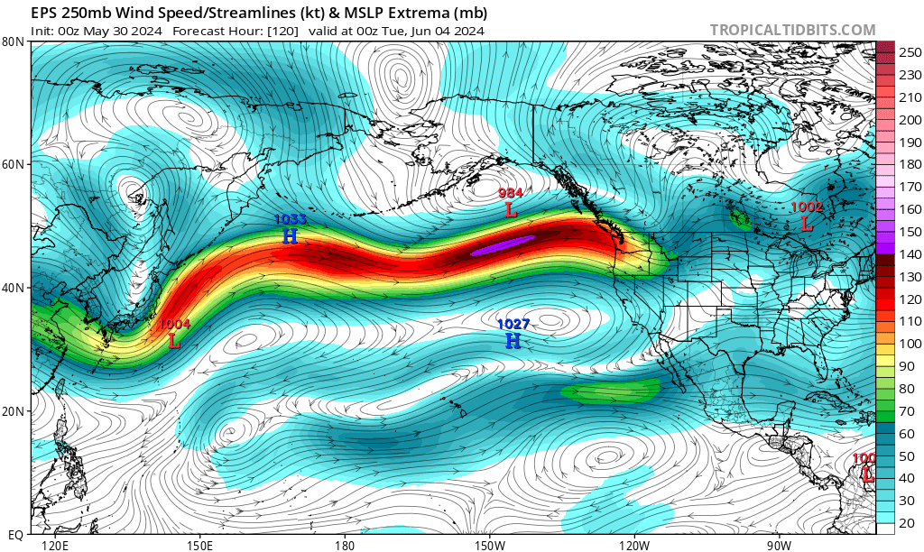
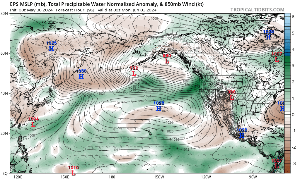
The first event of interest is already unfolding: a West Pacific tropical cyclone of modest strength is already beginning its northeastward recurvature as it transitions toward an extratropical state and injects some of its moisture and energy into the westerly flow across the North Pacific. The jet stream response to recurving TCs can be surprisingly robust even for relatively weak systems if ambient conditions are right, and that appears to be what is happening in this case. Downstream, this will cause a pretty unusual (for early June) extension of the Pacific jet across the entire North Pacific, with the jet exit region reaching the Pacific NW and British Columbia by Sun/Mon. A rather substantial late-season atmospheric river event will then unfold across the Pacific NW, with many places seeing 1-3+ inches of early summer rainfall. (Some lighter precip may even extend into far NorCal, esp. along the far North Coast.) As the jet retracts slightly westward thereafter, it will be in a favorable position for downstream “ridge building” over the western U.S. just a day or two later–and that’s exactly what will happen in the days thereafter.
Another interesting aspect to this sequence of events–i.e., the occurrence of a notably strong and atypical (for June) atmospheric river event in the PacNW/SW Canada followed immediately by a rapidly strengthening blocking ridge and subsequent major heatwave–is that it resembles in some key ways the lead-up to the June 2021 record-shattering heat event in the same region. There are currently no indications this upcoming event will be nearly as extreme as that historic event, but there are some striking structural similarities both in the pattern evolution and the potential contributors to severe heat.
The first may be a bit counterintuitive: the moist air associated with the atmospheric river, and (more importantly) the latent heat released via condensation as clouds and precipitation occur in this region, may actually help amplify the subsequent mid-tropospheric ridge by raising temperatures at upper levels of the atmosphere. (This occurs because of the “sensible heating”–literally, heat that “can be felt”–resulting from the phase change of water from the higher-energy vapor to lower-energy liquid (droplet) form). That warmer air aloft has the potential to become even warmer if it were to descend (dry adiabatically) toward the Earth’s surface, as tends to happen within the subsiding air near the center of high pressure systems. This mechanism (i.e., upstream latent heating) has increasingly been recognized as being an important factor in the development of many major heatwaves–perhaps even in the initial formation of blocking high pressure systems in the first place–and played a major role in boosting the June 2021 event to such extreme values. No two events are identical, but it is interesting to note that a similar process could potentially play out during the coming event.
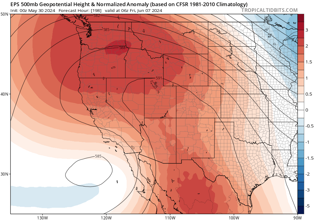
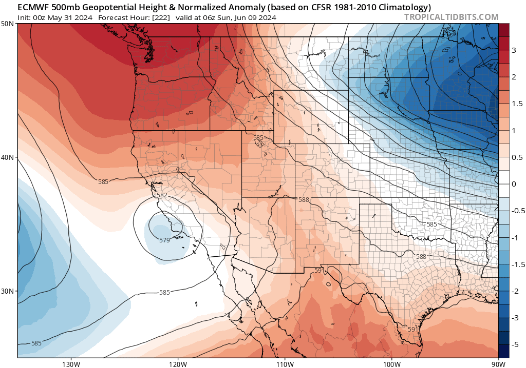
Major & widespread heatwave likely across much of western U.S. and Canada from early to mid June
There is high confidence that a major, widespread, and prolonged heatwave will develop across much of the interior Western United States and parts of western Canada by Jun 5-8 as a broad ridge of high pressure builds over the region. This likely means temperatures will be well above early-mid June levels across much of the region for a 10-14 day period, and could be record-breaking at times at least locally. There is still a pretty wide of potential outcomes, from “moderately hot” to “all time monthly June records,” depending on where you are and exactly how the pattern evolves. It does appear the region within 50-100 miles of the Pacific Coast is least likely to experience major heat with this upcoming pattern–partly because near-shore temperatures are so cool (cooler than average, even), and that will keep nature’s air conditioning going strong in all but the most extreme outlying ensemble member predictions. But there is also the potential for some inland regions that rarely see severe or prolonged early season heatwaves to experience one in the coming days, and this could bring substantial impacts. By Jun 10 or so, there may be a very large region of exceptionally warm temperatures extending all the way from central Mexico (where ongoing record heat is already having severe consequences) to western Canada (where already severe drought has yielded yet another early start to wildfire season).
How hot will it actually get in California? Well, the most anomalous heat will almost certainly occur away from the coast and probably across northern and eastern California. This means that most spots in the coastal SF Bay Area and coastal SoCal won’t get much more than “moderately warm” (and the immediate shoreline could remain under the cool influence of the marine layer!), but portions of the CA northern interior could actually break early season heat records. There may be a few days of very hot conditions for early June across the Sacramento Valley toward the middle of next week, but there will likely be a longer period of elevated heat across the northern mountains and Sierra Nevada eastward. So places like Shasta and Reno/Tahoe could be very (record?) hot by June standards, while San Francisco remains on the chilly side and places in between see a range of heat extremity. This will also represent the first major heat event the SE CA desert interior, though it’s less likely the heat there will be record-breaking as it sometimes does get quite hot there even in early June.
As noted below: there is still some notable uncertainty regarding the duration and westward extent of this heatwave–especially in its later phases. One thing that this heatwave will likely do regardless, however, is largely finish off the remaining Sierra snowpack (which had already faded at a notably rapid pace following near 100% of average values on April 1) and result in an uptick in wildfire activity as fuels rapidly start to dry out. I don’t foresee any extreme fire risk during this event–it’s still not dry enough, and there are no major winds expected–but we will start seeing more grass and brush fires during this period away from the coast and vegetation will start drying at a more rapid pace than usual for June.
Considerable uncertainty re: coastal CA conditions after initial warm days
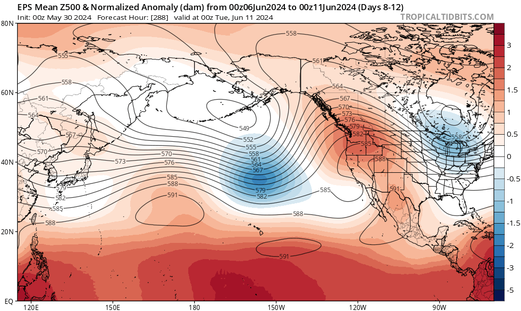
There is rather high confidence across multi-model ensembles that a fairly persistent (one might even call it “stuck”) weather pattern will likely persist across much of the Northern Hemisphere through mid-June (notably, this will likely be either a wavenumber 5 or 6 pattern–a setup recently under scientific scrutiny for being responsible for a disproportionate fraction of extreme weather events regionally and because there’s some evidence they may be increasing in a warming world). This means some kind of blocking ridge over the interior West/Pacific Northwest, along with paired upstream (over the NE Pacific) and downstream (over the eastern U.S.) troughs. The exact position of this ridge axis, and the upstream trough over the Pacific, however, will have large implications for conditions across California beyond Jun 7-8.
There has been a remarkable divergence between the individual operational runs of both the GFS and ECMWF and their respective ensembles in recent days, with the ensembles much more strongly emphasizing continued persistent ridging and heat across much of the West. But the operational runs have been suggesting that this ridge may shift eastward and be undercut by a highly anomalous (for mid-June) active Pacific jet–perhaps even bringing some June rainfall to the West Coast.
Additionally, and even in many ensemble members that depicted a continued strong West Coast ridge though mid-June, there are indications that a cut-off low pressure system may develop off the SoCal coast south of the blocking ridge and persist for some days. The most likely outcome of this low would be to mitigate heat close to the coast by amping up the marine layer, and perhaps to (contrarily) ratchet up the heat to the north and east of California away from the low center. But there would also be a slight chance, depending on the details, that a cut-off in such a position could entrain just enough mid-level moisture and generate just enough instability for some isolated convective activity on its northern and eastern flank (i.e., perhaps some isolated thunderstorms over portions of CA). That would not be unheard of for June, though it’s also not the most likely solution at this point.
On the other hand, there are yet a few other ensemble members that depict the ridge expanding and intensifying even more strongly over California–which would bring more widespread heat. So despite much confidence in the overall continental-scale pattern this period (including its blocky-ness and high potential for persistent anomalous heat across the interior West of U.S. and Canada), when it comes to California conditions by mid-June could potentially run the gamut from a prolonged heatwave to unusually cool or even locally rainy conditions. How’s that for a range of outcomes? I think this wide ensemble spread is likely being caused by the “stickiness” of the pattern, which tends to yield “weird” results in one direction or another–partly a result of such systems sometimes acting as “strange attractors” and yielding bifurcated ensemble plumes under initial condition uncertainty. Well, one thing is certain: there sure has been some fun language in this blog post!
The post Complex weather pattern to bring notable early-season heatwave across West, including parts of California first appeared on Weather West.